


Port Jackson was only 30 years old when John Oxley, Surveyor-General of the Territory, discovered the Liverpool Plains on his second inland expedition.
Oxley and his party had set out from Bathurst in May 1818 to fulfill Governor Lachlan Macquarie’s Grand and Primary Objects (of the Expedition) – to find the Real Course and Direction of the Macquarie River, whether it ran into the sea or an inland lake, whether the junction was suitable for a port for shipping or settlement and to carefully note and examine the appearance and particulars of the countryside, its soil, woods, natural features and fauna.
Included in Oxley’s party were second-in-command George William Evans (Deputy Surveyor-General), Charles Frazer (Colonial Botanist), John Dwyer (boat-builder), James Williams (blacksmith), plus butchers, horse drivers and labourers. Sixteen packhorses carried provisions for 15 people for 24 weeks – 2880 pounds of flour, 1440 pounds of salt pork, 350 pounds of sugar, 350 pounds of rice, 90 pounds of tea (in two kegs), 45 pounds of tobacco (in a case), 50 pounds of salt, 12 pounds of arrowroot, 3 pounds of pepper, 20 pounds of soap and 20 pounds of wax candles. They also carried one light tent, a piece of canvas for making bags, 14 muskets (with 50 spare flints), 400 rounds of ball cartridges, 20 pounds of fine powder, six powder horns, 30 pounds of buckshot, three cutlasses, 15 quart tin pots, 15 clasp knives, 12 pewter plates, four frying pans, three felling axes, six tomahawks, one crosscut saw, two reaping hooks, 15 suits of winter slop-clothing, 15 pairs of blankets, 30 extra shirts, 30 extra pairs of shoes, 24 fishing lines, 100 common needles and 12 sail needles and rope, twine and thread.
The inclusion of a boat-builder was significant as the party intended to carry its provisions as much as possible by water – and, of course, the boats would have been essential if the journey led to an inland sea.
When the river and its environs made it too difficult to use boats, the party had to travel overland, carrying the boats, which meant that the horses were extremely overloaded. Many of them perished and provisions had to be discarded along the way.
Oxley and his party left Bathurst on June 6, 1818, following the Macquarie until they reached extensive swamp country (Macquarie Marshes), where their progress was halted by widespread flooding. But instead of retracing their route back up the Macquarie, they then struck north-east and east, crossing the Warrumbungle Ranges and passing through the Pilliga Forest before reaching the Liverpool Plains. Their first view of the vast grazing lands, which Oxley named the Liverpool Plains, occurred in the 16th week of the arduous trek, as the party descended from the Warrumbungles, Oxley recorded that he and Dr John Harris had ascended “an elevated conical hill” from which they saw “hills, dales and plains of the richest description”.
“We seemed to be once more in the land of plenty and the horses as well as the men had cause to rejoice at the change from the miserable harassing deserts through which we had been struggling for the last six weeks, to this beautiful and fertile country.”
John Oxley then recorded in his diary:
August 29th. On our departure (from View Hill, now Dimberoy Hill) we almost immediately descended a rocky and steep hill, covered with cypress and small brush: from thence we descended upon a level forest country which continued for the remainder of our journey (seven miles) to the edge of the extensive flat which we had seen yesterday. As we should not have been able to cross the flat before nightfall, I thought it better to remain where there was plenty of grass and water.
“From our tent we had a singularly picturesque and pleasing view. To the north Hardwick’s Range (now Nandewar Range), distant between forty and fifty miles, the country broken into low forest hills and plains to its base. To the north-east and south east, our view was bounded by beautiful forest hills seldom rising to any great elevation, thinly wooded and covered with grass. These hills bounded the plains and varied in distance from ten to thirty miles.
To the north-east the country was lowest but appeared good and open: that part of the plain near which we encamped was wet and marshy and the horizontal level of the whole appeared to warrant the supposition that at some not-too-distant period, these vast plains formed chains of inland lakes, which the washings from the hills have nearly filled up.
The hills passed over this day were of a curious species of puddingstone and freestone. The hills on the opposite side of the plains were named Melville Hills in honour of the First Lord of the Admiralty, and the valley at the extremity of it was named Barrow’s Valley (now Mooki River Valley).
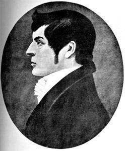
Explorer John Oxley, first to report on the Liverpool Plains during his expedition in 1818.
“August 30th: A day of rest and refreshment to ourselves and horses. Game abounds and our dogs abundantly supply us. The observations made here place our situation in lat. 31.7: long. 150 E.
“August 31st. We were agreeably disappointed in finding that the wet, marshy ground did not extend above three quarters of a mile, the remainder being dry, firm land of the richest description. At six miles we crossed a considerable stream, running to the north through Barrow’s Valley: this stream divided the plain into two equal parts, it being ten miles and a half across. The stream had recently been flooded and the water, yet muddy, had not subsided within its proper level, the height of the banks from 15 to 20 feet.”
These rich and beautiful plains Oxley named Liverpool Plains, after the then British Prime Minister.
In his Journals of Two Explorations into the Interior of New South Wales, Oxley painted a picture of “a land of plenty” (Liverpool Plains), a patchwork of grasslands and timber, of broad, flat valleys and gently rising hills.
His description of the plains country was in stark contrast to that of the (East) Pilliga Scrub through which he had passed immediately beforehand. “So thick was the forest (Pilliga) that we could hardly turn our horses, nor could the sun’s rays penetrate to the sandy desert on which the trees grew,” and “the country seemed abandoned of every living thing,” he wrote.
Oxley’s discovery of new grazing country created new interest in the land ‘beyond the 19 counties’ which was then bounded by the Great Dividing Range.
Oxley came to the Liverpool Plains from the south-west but settlement was to come from the Hunter Valley, where pastoralists were frustrated by their increasing stock numbers and limited pastures.
Explorer Allan Cunningham passed through the region from the south, through Pandora’s Pass, in 1823 and Henry Dangar led the way over the Great Dividing Range at Doughboy Hollow in 1824. William Nowland was the first to take a dray over the Murrurundi crossing (Page’s River Pass) to the Liverpool Plains. The squatters followed and by 1827, there were three stations on the eastern Liverpool Plains.
European settlement of the region had begun.
Extract from Gunnedah & District Historical Society’s Sesquicentenary book The Way We Were


