Gunnedah and its surrounds have been identified as ‘high risk’ in the event of bushfire according to a draft plan recently released for public feedback.
The Liverpool Range Bush Fire Risk Management Plan identifies bush fire issues, identifies assets at risk, assesses the level of risk, and establishes treatment strategies to minimise the risk.
Under the draft plan, five ‘focus areas’ within the Liverpool Range were identified for special attention.

These areas include Gunnedah and surrounds, Premer, Caroona and surrounds, Tomalla, and Merriwa.
These areas have been specifically identified as having an unacceptable risk and require additional, targeted treatment strategies.
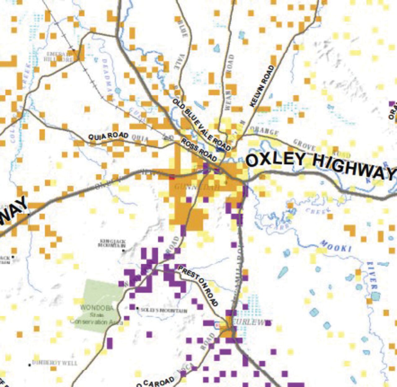
Under the risk profile, the majority of Gunnedah homes and property are in the high risk category – the second highest on the five-level risk rating.
“There is a high risk to economic assets in the area, particularly agricultural assets surrounding the community, Black Jack State Forest and the industrial estate in the towns western precinct,” the report states.
“The communities and businesses in and around Gunnedah are also vulnerable to loss of infrastructure (power) and may be impacted by a prolonged incident.”
The plan highlighted “special fire protection considerations” include the aged care facility on the town’s eastern edge with a moderate bush fire risk rating.
The management plan also identified an “upward trend” of human ignitions in the Gunnedah area.
“In particular from the burning of stolen vehicles to the west along the Oxley Hwy. Consideration has been given to managing the spread of ignitions through the use of strategic transport corridor fire breaks across the Bush Fire Management Committee (BFMC) area,” it stated.
It was assessed as a moderate risk that a bush fire could harm the cultural value of Aboriginal sites in the area.
An objective of the management plan in the Gunnedah and surrounds is to improve community preparedness, particularly, the maintenance of private asset protection zones and the preparation of bush fire survival plans.
“This will be achieved through the provision of resources and the implementation of programs that will help residents better understand their risk and prepare for bush fire,” the report stated. “In addition, prescribed burning will be implemented to achieve strategic fuel management and minimise risk to the residential, environmental, and economical assets in the area. These will be maintained by the responsible individual land managers and reported to the BFMC.
For the purpose of the fire management plan, the Gunnedah and surrounds focus area incorporates the Gunnedah township, south along the Kamilaroi Highway to the village of Breeza. The area includes Black Jack State Forest and the Wondoba Community Conservation Area along with isolated rural residential communities.
The vegetation throughout this area is predominantly grassland and dry sclerophyll forest which contributes to the bush fire risk and the potential for significant fire development, according to the draft plan.
Many other areas in the Liverpool Range zone, such as Merriwa, are also at high risk.
“The majority of homes and properties are isolated rural communities or single dwellings, and many are identified in the high bush fire risk category,” the Merriwa risk profile noted.
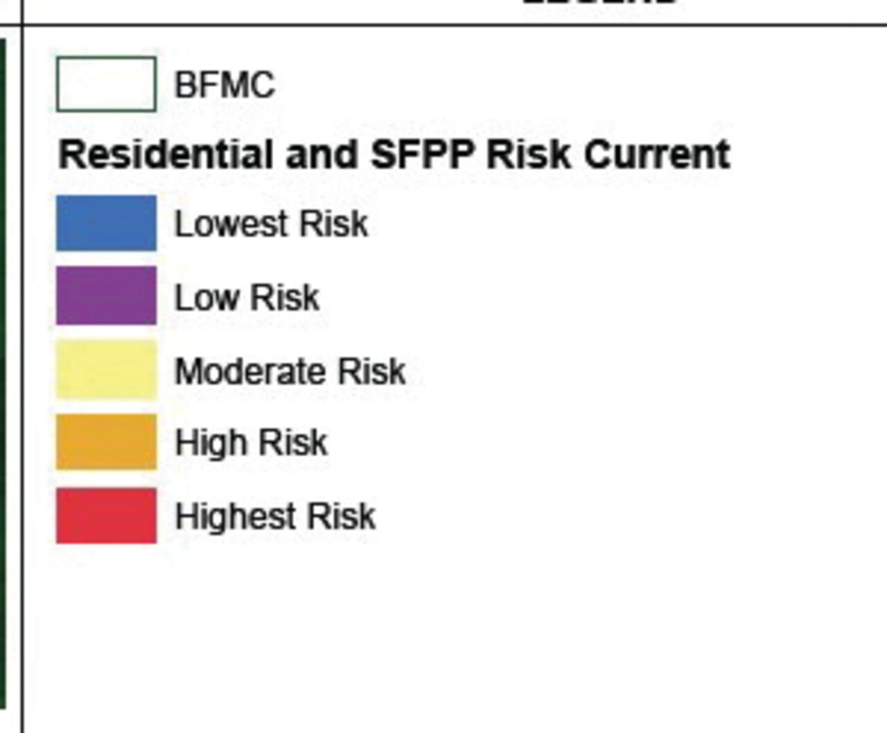
Residential & SFPP Risk – Current
The Residential & SFPP Risk – Current map shows the modelled risk to homes or special fire protection purpose assets across the BFMC when risk modelling commenced for this plan. Assets considered as special fire protection purpose include: schools, child care centres, universities, hospitals, retirement villages, accommodation buildings, prisons, churches, halls and other public buildings where the public are likely to assemble. Each coloured square on the map represents the risk to a home or a group of homes or special fire protection purpose asset. To determine the risk, a 180m grid was created across the BFMC area and all grids where homes or special fire protection purpose assets were present were identified. Then the likelihood of a bush fire starting, spreading and reaching the asset was determined and combined with the potential damage to these assets given the likely fire exposure at each grid to calculate the risk. For the risk to houses, the number of homes in the grid was also used to calculate the risk. This means that the risk results are influenced by housing density. If two grids have the same likelihood of a bush fire starting, spreading and damaging homes but one grid has three houses and the other only one, then the grid with three houses will be three times the risk of the grid with one house. The 180m grids are aggregated to 540m (i.e. nine grids together) and the risk values summed to calculate the risk for the larger grid size. The data is then classified into a maximum of five categories from lowest to highest based on their risk value. If the aggregated grid had both houses and special fire protection purpose assets, then the highest risk category is shown on the map.
The map displays the comparative risk across the BFMC area from a landscape perspective, that is, where in the BFMC are the highest risk area compared to other areas. If a house or special fire protection purpose asset is located in the lowe